


File:Battle of Britain map.svg


Size of the above preview of this SVG file: 500 × 627 pixels. Other resolutions: 250 × 314 pixels | 960 × 1,204 pixels | 1,920 × 2,409 pixels.
Original file (SVG file, nominally 841 × 1,055 pixels, file size: 240 KB)
This is a file from the Wikimedia Commons. Information from its description page there is shown below.
Commons is a freely licensed media file repository. You can help.
Commons is a freely licensed media file repository. You can help.
Summary
| Description |
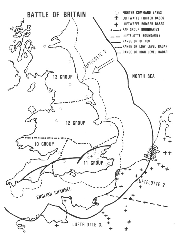
English: Battle of Britain boundaries, bases and RADAR coverage. |
| Date | |
| Source | Image from Strategy for Defeat, The Luftwaffe 1933-1945 by Williamson Murray |
| Author | Hohum |
| Other versions |
Derivative works of this file: |


Licensing

|
I, the copyright holder of this work, release this work into the public domain. This applies worldwide. In some countries this may not be legally possible; if so: I grant anyone the right to use this work for any purpose, without any conditions, unless such conditions are required by law. |
File history
Click on a date/time to view the file as it appeared at that time.
| Date/Time | Thumbnail | Dimensions | User | Comment | |
|---|---|---|---|---|---|
| current | 23:12, 26 February 2024 | | 841 × 1,055 (240 KB) | Hohum | Lighten make text and symbology stand out more. |
| 01:05, 20 February 2010 |  | 841 × 1,055 (241 KB) | Hohum | Recoloured | |
| 20:02, 24 July 2009 |  | 800 × 1,025 (276 KB) | Hohum | {{Information |Description={{en|1=Battle of Britain boundaries, bases and RADAR coverage.}} |Source=Own work by uploader |Author=Hohum |Date=July 2009 |Permission= |other_versions= }} |


File usage
The following 9 pages use this file:
Global file usage
The following other wikis use this file:
- Usage on ast.wikipedia.org
- Usage on azb.wikipedia.org
- Usage on ca.wikipedia.org
- Usage on cs.wikipedia.org
- Usage on de.wikipedia.org
- Usage on en.wikiquote.org
- Usage on es.wikipedia.org
- Usage on fi.wikipedia.org
- Usage on fr.wikipedia.org
- Usage on he.wikipedia.org
- Usage on io.wikipedia.org
- Usage on it.wikipedia.org
- Usage on no.wikipedia.org
- Usage on pt.wikipedia.org
- Usage on ro.wikipedia.org
- Usage on ru.wikipedia.org
- Usage on sk.wikipedia.org
- Usage on ta.wikipedia.org
- Usage on vi.wikipedia.org
