Category 5 Hurricane Polo among most intense E. Pacific storms on record

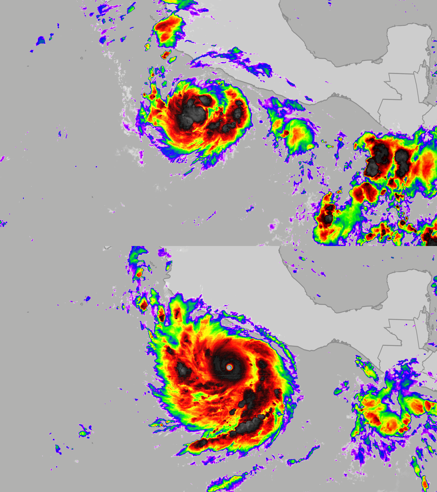
Hurricane Polo not only exploded into a Category 5 hurricane Tuesday just one day after it was a tropical storm, but it later became one of the most intense Eastern Pacific hurricanes on record while hovering off the coast of Mexico.
(MORE: Hurricane season tracking maps)
The timeline
Monday morning, Tropical Storm Polo was located about 200 miles off Mexico's Pacific coast, with winds of 50 mph.
Just 24 hours later, Hurricane Polo reached Category 5 intensity. That's the strongest category on the Saffir-Simpson Hurricane Wind Scale.
You can see the explosive growth in the satellite loop above, put together by senior meteorologist Jonathan Belles.
Notice Polo going from a few thunderstorm clusters Monday to an ominous, classic intense hurricane with a tiny eye.
But early Tuesday afternoon was a mic drop moment.
A NOAA hurricane hunter mission found Polo had gained even more strength, with winds of 180 mph and a central pressure of 892 millibars.
(MORE: Hurricane Polo interactive forecast map)
Polo's historic perspective
That combination of both deep low pressure and winds made Polo the strongest tropical cyclone anywhere on Earth so far in 2026.
Western Pacific super typhoons Sinlaku in mid-April and Bavi in early July each had maximum estimated winds of 180 mph. But Polo's low pressure early Tuesday afternoon was lower than the lowest estimated pressures of both Sinlaku (896 millibars) and Bavi (901 millibars).
Any hurricane with a surface pressure below 900 millibars is in elite company.
Only one other Eastern Pacific hurricane accomplished that feat in reliable records dating to 1971. That was late October 2015's Hurricane Patricia, which bottomed out at a Western Hemisphere record 872 millibars, along with 215 mph peak winds.
Only two Atlantic hurricanes have had lower pressures: Wilma in 2005 (882 millibars) and Gilbert in 1988 (888 millibars).
Polo's early Tuesday afternoon pressure (892 millibars) matched the lowest pressure of Melissa in 2025 and the estimated pressure of the 1935 Labor Day hurricane in the Florida Keys. Melissa ended up tying the Atlantic Basin all-time wind record (190 mph winds), as well.
Polo's peak winds exploded by a whopping 110 mph in 24 hours from Monday morning through Tuesday morning.
That's just 10 mph shy of the world record 24-hour rapid intensification by wind speed, a 120 mph leapHurricane Patricia made before it slammed into Mexico.
Rapid intensification is also measured by how much a hurricane's central pressure dropped.
Advertisement
Polo's central pressure dropped 82 millibars in 22 hours from Monday afternoon through early Tuesday afternoon, less than the Eastern Pacific 24-hour record from Patricia (97 millibar plunge) and the global 24-hour record from 1983's Super Typhoon Forrest in the Western Pacific (100 millibar pressure drop).
Why did this happen?
Some tropical storms struggle to intensify much at all.
We've seen that repeatedly in the 2026 Atlantic hurricane season, due in large part to an intensifying El Niño.
But when there's low wind shear, humid air and deep, warm ocean water, a storm can undergo rapid intensification.
Meteorologists define that as an increase in a tropical storm or hurricane's maximum sustained winds of at least 35 mph in 24 hours or less.
Those favorable conditions were all in place for Polo, and this explosion was forecast well by both the National Hurricane Center and computer forecast models.
On Monday, NHC senior hurricane specialist Eric Blake wrote that one rapid intensification index was "showing percentages as high as I have ever seen."
One other factor is Polo's size. Small storms can both intensify and weaken more rapidly than larger storms.
That's because small storms like Polo can concentrate heating from both its thunderstorms, the air and ocean near its center more efficiently than expansive, larger storms.
(IN DEPTH: Rapid intensification)
Why this matters
This isn't just academic. When this happens near landfall, it can be catastrophic.
Three years ago, Hurricane Otis exploded from Category 1 to Category 5 just before its landfall in Mexico.
The resort city of Acapulco was prepared for a Category 1 landfall, not the city's strongest hurricane on record.
Otis' last hour bolt to Category 5 led to Mexico's costliest weather disaster, with more than 131,000 homes destroyed or seriously damaged.
And, as we previously wrote, rapid intensification is becoming more common.
A 2023 study found Atlantic Basin hurricanes are twice as likely to rapidly intensify as they were 30 years ago.
If you're in a hurricane-prone area, this is why it's important to check the forecast for updates.
You don't want to get caught in a much stronger hurricane when it was a tropical storm just a day or two earlier.
Jonathan Erdman is a senior meteorologist at weather.com and has been covering national and international weather since 1996. Extreme and bizarre weather are his favorite topics. Reach out to him on Bluesky, X (formerly Twitter) and Facebook.